IMMAGINA
It is the utmost solution for drone topography.
Measuring small or large ground extents has never been so immediate and easy.
With IMMAGINA, you can get a topographic survey even less than thirty minutes.
Easy to use - intuitive and easy to use for beginners, designed by surveyors for surveyors.
Flexible - With a single software, you can realise a classic photogrammetry, a punctual topography of vast areas and much more in a short time
Reliable – People, who do your same job, will assist you in the software use
Request the TRIAL for free!
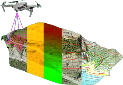
How does it work? In 5 steps:
- You will define on Google Earth the area to be detected and the software will plan the whole mission on the APR
- Automatic execution of the plan of flight and necessary picture shots collection
- Downloading photos on the PC and processing photogrammetric until obtaining the orthophoto mosaics and the point cloud
- Realising all topography works just working on your PC, deciding which points to pulse, choosing the real DTM and eliminating elements such as trees roofs etc., creating dimensioned plans, with discontinuity lines, profiles and such
- Give your client both standard topographic works as scaled orthomosaics dimensioned plane, contour lines, profiles, sections and such but also the cloud file, orthomosaic in scale, 3D model in BIM format and/or GIS, 3D printing file
What we can offer:
- All our experience and knowhow within our reference sector
- Nowadays many similar technicians perform the same activity. This fact leads you to enhanced professionalism and profit
- With IMMAGINA, you can distinguish yourself from competitors and acquire new, qualified customers
- IMMAGINA is an integrated system, which allows you to perform topographic activities and getting trustworthy measurements that you personally selected
There are a many, which cannot be listed all here however, as a starting point in order to understand its huge potential:
- The Classic Photogrammetry
- Quick Punctual topography of small and large areas
- Volume Calculation for quarries and Dumps
- Land Surveying for general projects or civil works such as roads, canals, lots, urban expansion, and execution
- Land Surveys on inaccessible areas
- Geological surveys
- Landslides and Monitoring
- Land check and verification after natural events such as fire, flood, storms, earthquakes, etc
- Photography for inspections on inaccessible areas
- Professional videos
- Photographic documentation for appraisals and causes
 |
 |
||
YOU CAND FIND MORE INFORMATION AND CASE STUDIES AT
https://dronetopoprogram.eu
| Brochure |